
Spectrum Sharing Innovation Test-Bed
The National Telecommunications and Information Administration (NTIA), in coordination with the Federal Communications Commission (FCC) and the Federal agencies, established a Spectrum Sharing Innovation Test-Bed (Test-Bed) pilot program to examine the feasibility of increased sharing between Federal and non-Federal users. This pilot program is an opportunity for the Federal agencies to work cooperatively with industry, researchers, and academia to objectively examine new technologies that can improve management of the nation's airwaves.
Test-Bed Pilot Program
The Test-Bed Pilot Program will evaluate the ability of Dynamic Spectrum Access (DSA) devices employing spectrum sensing and/or geo-location techniques to share spectrum with land mobile radio systems operating in the 410-420 MHz Federal band and 470-512 MHz non-Federal band. The Test-Bed Pilot Program will be performed in three phases:
1) Equipment Characterization. Equipment employing DSA techniques will be sent to the NTIA Institute for Telecommunication Sciences in Boulder, Colorado and characterization measurements of the DSA capabilities in response to simulated environmental signals will be performed.
2) Evaluation of Capabilities. After successful completion of Phase 1, the DSA capabilities of the equipment in the geographic area of the Test-Bed will be evaluated.
3) Field Operation Evaluation. After successful completion of Phase 2, the DSA equipment will be permitted to transmit in an actual radio frequency signal environment. An automatic signal logging capability will be used during the operation of the Test-Bed to help resolve interference events if they occur. A point-of-contact will also be established to stop Test-Bed operations if interference is reported
Test-Bed Participants:
- Adapt4 LLC
- Adaptrum Inc.
- BAE Systems
- Shared Spectrum Company
Related content
Satellite Technology and Spectrum Key to Better Weather Forecasting
Ten years ago, one of the deadliest hurricanes in history struck the Gulf Coast, decimating coastal cities and communities from Gulfport, Miss., to New Orleans. At the time, the National Weather Service (NWS), an agency of the U.S. Commerce Department’s National Oceanic and Atmospheric Administration (NOAA), accurately forecasted more than two days ahead of time that the central Gulf Coast would be directly impacted by Hurricane Katrina. While this forecast undoubtedly helped limit the loss of life and property, communities across the Gulf Coast still suffered billions of dollars in damage and hundreds died in the storm’s aftermath, according to NOAA’s National Climatic Data Center.
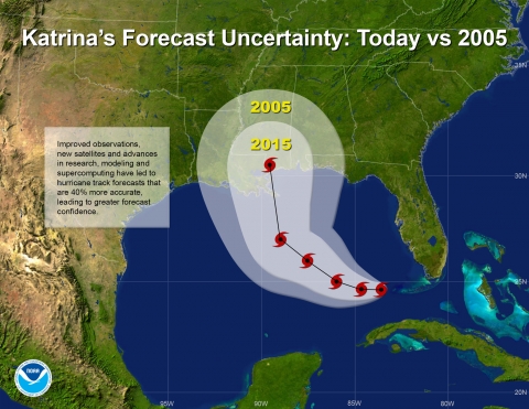
A comparison of the cone of uncertainty given 2005 forecasting capability and 2015 forecasting capability.
Understanding Federal Spectrum Use
In recent days, there has been a great deal of discussion about how much spectrum federal agencies use and whether that spectrum is being used efficiently. This is an important conversation to have and one that goes to the heart of NTIA’s statutory mission of fostering full and efficient use of the nation’s spectrum resources in a manner that most benefits the public interest. If we are to make progress toward a more efficient use of spectrum, it is also essential that this discussion include a full and balanced assessment of the challenges and trade-offs that must be addressed.
Nearly Halfway to Meeting Spectrum Target
Recognizing the growing importance of wireless broadband to the U.S. economy, President Obama five years ago last week set a bold new goal aimed at ensuring that enough spectrum is available to meet the surging demand for wireless connectivity. As the President noted in a June 28, 2010 memorandum, “The world is going wireless, and we must not fall behind.” The President called on NTIA and the Federal Communications Commission (FCC) to make 500 megahertz of federal and non-federal spectrum available for commercial wireless broadband by 2020. As we move into the second half of this ten-year challenge, I wanted to take the opportunity to review the progress we have made and the hurdles still left to surmount.
Five years out, there is little debate about the accuracy of the President’s prediction – the public’s demand for wireless “smart” devices has continued to grow exponentially along with the need for spectrum to help power this technology. Nearly two-thirds of Americans now own smart phones compared to just 35 percent in 2011, according to the Pew Research Center.