
Spectrum Pipeline Reallocation Engineering Study Follow-On: TASK 3 — Identifying Regulatory Constraints
Executive Summary
The National Telecommunications and Information Administration (NTIA) concludes in this report that it is technically feasible to share the 1675-1680 MHz band used by the National Oceanic and Atmospheric Administration (NOAA) for transmission of time-sensitive satellite data with commercial wireless services. In 2016, the Federal Communications Commission (FCC) issued a Notice of Proposed Rulemaking to consider sharing of the 1675-1680 MHz band between new commercial mobile operators and incumbent NOAA satellite operations.[i] In response, in October 2020, NOAA published the Spectrum Pipeline Reallocation Engineering Study (SPRES) Report (SPRES Report)[ii] that studied the potential impact on NOAA operations of possibly sharing spectrum with new commercial operations in the 1675-1680 MHz band. This instant report is intended to address the further study topics suggested in the SPRES Report and concludes that spectrum sharing is possible by employing “coordination zones” around five “DCS” earth stations and then transitioning the remaining earth stations to an alternative distribution method.
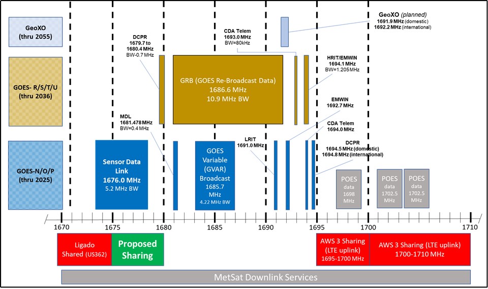
Figure 1 shows the current and proposed frequency usage for this band.
The SPRES Report addressed the impact of sharing on three aspects of NOAA data distribution operations: (1) High-Rate Information Transmission (HRIT); (2) Geostationary Operational Environmental Satellites (GOES) ReBroadcast (GRB); and (3) the Data Collection System (DCS).
HRIT: The SPRES Report found that spectrum sharing presents low risk of causing impacts to HRIT given the frequency separation.
GRB: The SPRES Report found that the GRB signal is at some risk of radio-frequency interference (RFI) at the ground stations, more so from commercial base station operations (downlinks) than from commercial user devices (uplinks).
DCS: The SPRES Report found that the most significant obstacle to spectrum sharing involves radio-frequency interference from downlink commercial operation to DCS ground stations. If the commercial operations are restricted to uplinks, however, sharing may be manageable with modest protection zones.
To reach a more definitive conclusion regarding the potential for sharing the 1675-1680 MHz band with commercial mobile, the SPRES Report suggested:
further technical compatibility analysis to determine specific technical limits on commercial mobile operations to insure protection for the key DCS sites and certain GRB and HRIT sites. This latter work would consider limits on such things as the radiated power and out-of-band emissions of the commercial mobile system’s transmitters and any guardband that might be used to limit in-band energy in protection zones around the DCS, GRB, or HRIT receiver sites.[iii]
This instant report is intended to address the further study topics suggested in the SPRES Report. NTIA’s technical assessment is that sharing the 1675-1680 MHz band with non-federal wireless services is technically feasible. Federal earth stations would be protected from harmful interference by employing “coordination zones” around five DCS ground stations and then transitioning the remaining DCS ground stations to an alternative distribution method. It is estimated that, in such a manner, commercial service could be provided for 80-90 percent of the population of the continental United States.
Protection of Federal Systems from Harmful Interference that Sharing Could Cause. To protect the federal earth stations from harmful interference that otherwise could result from sharing the spectrum, this report provides the methodology to be used in a coordination process, along with the technical characteristics of federal earth station operations. A “coordination zone” would be established as an area in which wireless terrestrial commercial operators would need to coordinate with NTIA before they could deploy a base station within that coordination zone. Commercial operators would need to coordinate for a particular base station only once. Spectrum sharing in these coordination zones would not be time dynamic. Specifically:
- Five DCS ground station locations would be protected using coordination zones. All other DCS ground stations would transition to use an alternative distribution method to maintain access to the DCS data.
- If an alternative distribution method could not be applied to GRB data, an additional 14 GRB locations would be protected using coordination zones.
- No HRIT locations would need to rely on the protection of coordination zones.
To adequately protect federal incumbents, NTIA recommends that the coordination zones be identified on the NTIA website (as was done for the 3.5 GHz Citizens Broadband Radio Service),[iv] allowing for future modification of federal coordination zones if changes in non-federal operational use so warrant.
Future Work to Advance Spectrum Sharing. To advance spectrum sharing (at the Hunt Valley DCS location), future efforts could consider whether earth stations could share in the time domain, with potential use of an incumbent informing capability (IIC) optimized for time-based spectrum sharing.[v] The IIC can be a near-real-time mechanism to inform non-federal users in a shared spectrum band when incumbent federal systems need to be protected from harmful interference.
[i]Allocation and Service Rules for the 1675–1680 MHz Band, Notice of Proposed Rulemaking, 34 FCC Rcd 3552 (2019).
[ii] U.S. Department of Commerce. National Oceanic and Atmospheric Administration. National Environmental Satellite Data Information Service, Spectrum Pipeline Reallocation 1675–1680 MHz Engineering Study (SPRES) Program Report. Silver Spring, MD: NESDIS, October 2020 (“SPRES Report”), https://www.fcc.gov/ecfs/document/10906163747708/1 .
[iii] SPRES Report at ii.
[iv]See Letter from Paige Atkins, NTIA, to Julius Knapp, FCC, Docket No. 12-354 (Mar. 24, 2015), https://www.ntia.gov/files/ntia/publications/ntia_letter_docket_no_12-354.pdf (regarding commercial operations in the 3.5 GHz band).
[v]See NTIA Report, Incumbent Informing Capability (IIC) for Time-Based Spectrum Sharing (2021), https://www.ntia.gov/report/2021/ntia-report-incumbent-informing-capability-iic-time-based-spectrum-sharing.